The Garibaldi at Squamish project is proposed to build a mountain resort on Brohm Ridge ( the map area), the total proposed area of this project is about 54.70 sqkm. The site is located 15 km north of Squamish on Highway 99. It is 80 km north of Vancouver and 45 km south of Whistler, there are multiple roads in this area (indicated by black lines in the map). In this site, about 70% of the area has elevation higher than 555m, which ensures there will be enough snow for 124 ski trails. Also, there are about 6.78% of the area is old growth forest, 4.23% is habitat of mule deer, 3.65% is mountain goat habitat, and 30.14% is fish bearing streams, those protected area takes up to total of 40.38% of the area, which means 59.62% can be used as proposed area for ski resort. Among those 59.62% of area, 70% has the elevation higher than 555m, so 41.73% of the area (about 22.82 sqkm) is the ultimate solution for the site selection.
- Acquire data of forest and ungulate area from DataBC, and familiarly manipulate TRIM data.
- A geodatabase was create to store and organize data.
- All layer from different sources were reprojected to UTM Zone 10N_NAD83 to represent this area.
- The DEM layer was clipped to the shape of project boundary to provide a clean look of the relevant subject.
- The DEM layer of this area was reclassified based on elevation to indicate the area with snow.
- The river of this area was buffered with 50m above elevation of 555m and 100m below elevation of 555m to show the fish bearing stream area.
- Merged forest layer, ungulate area layer and fish bearing layer to generate protected area layer and calculated the area of this layer to show the percentage of area can be used in the project.
There may be some error caused by data collection, because the datasets were published in 2018 Feb & Aug, however the researchers and government may update it in the future, so the map of suggested site is only valid in recent years. And other error may caused by incomplete information. For example, in the current map area, the aboriginal reserved areas have not be marked. Also, the project needs to take consideration of the public ideas from online survey.
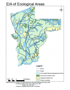

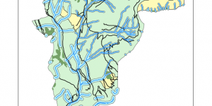
Full image.EIAecologicalareas EIAhillshade
--Acquire data of forest and ungulate area from DataBC, and familiarly manipulate TRIM data.
--A geodatabase was create to store and organize data.
--All layer from different sources were reprojected to UTM Zone 10N_NAD83 to represent this area.
--The DEM layer was clipped to the shape of project boundary to provide a clean look of the relevant subject.
--The DEM layer of this area was reclassified based on elevation to indicate the area with snow.
--The river of this area was buffered with 50m above elevation of 555m and 100m below elevation of 555m to show the fish bearing stream area.
--Merged forest layer, ungulate area layer and fish bearing layer to generate protected area layer and calculated the area of this layer to show the percentage of area can be used in the project.